If asked which words one associated with the Sahara, only the most dedicated surrealist might be expected to offer "whale”. - Eamonn Gearon
5 March 2020, Bon Lanuar, MAURITANIA to Guerguerat, WESTERN SAHARA / MOROCCO, 55.6km
Hotel Lamlaga 200MAD (R320)
Exchange rate: Rand 1 (R): Moroccan Dirham 0.62 (MAD)
We awoke to a chilly, misty morning, the wind having shifted to northerly from easterly, thus putting paid to our hopes of being blown to the intersection before the turn to the border.
The N2 turns sharply west at Bon Lanuar, and travels due west for almost 40km before turning north again to cross into Western Sahara. We had dreamed of the easterly wind, which has bothered us since Senegal, blowing us west in record time. But it was not to be. Luckily, the northerly wind blew just a tad behind us, so was not a particular hindrance.
As we exited the hotel, just across the road, were a small cluster of camels, old and young, romantic in the mist.
We breakfasted on a yoghurt drink, banana-flavoured, and stocked up on soft drinks and water and dates and fresh warm bread, before heading out.
The road was in good condition, as has been the case most of the time since Nouakchott, the sun rising behind us and throwing our shadows long in front of us, but later onto the sand to our north. We cycled beside then past solar panels behind a fence and wind turbines standing proud but running slow in a single line parallel to the road. And past signs to two or three auberges and a campsite, none mentioned by previous travellers. And beside the 704km-long railway line that links the iron mining centre of Zouerate (British company Glencor Xtrata) with the port at Nouadhibou on its long peninsula. Operational since 1963, the line carries some of the longest and heaviest trains in the world. Trains can measure 2.5km with 200-210 cars, each carrying up to 84 tons of ore. People can, if they wish, travel for free on top of the ore, but the conditions - heat, cold, wind - are harsh and deaths from falls apparently common. On occasion, there are passenger cars attached.
We met an Austrian travelling in a four-wheel drive truck into a camper. We met him because he was stuck in the sand just a couple of metres off the road. He had turned off to find a spot from which to film the train. He was not stressed about his situation, saying he would simply deflate his tyres and be out of trouble. And not long after, he passed us. And not long after, we passed him again at a new place he had chosen his photographs. Last year he travelled from Europe to Togo, leaving his vehicle there during the summer and picking it up again this year for the trip back home. His girlfriend had flown home from Dakar. We were to see him twice more: once after we turned north to the border, he overtaking us again, and once at the border where he had been much delayed as are all those travelling by car or truck or bus.
We took brief breaks at each distance marker, drinking water at the 5km markers and treating ourselves to bread and honey or dates or soft drinks at the 10km markers. We had one puncture, and were stopped a couple of times by gendarmes seeking “fiche” (copies of our passports). When we told them we did not have any left, keeping what we did for the border, they were not too bothered, certainly not enough to record our details in their log-books, or on scraps of paper as has sometimes been the case.
At the intersection - left to Nouadhibou, right to Dakhla in Western Sahara - we spent the last of our small change Ouguiya: 20 on a Melon Milk, 10 on loose cigarettes, three Marlboros. While there, we met two of five young European men hitching together with no particular plan or destination in mind. A Dane with a windmill on his cap and a ginger beard, a Spaniard dressed in a long tunic and turban (cultural appropriation?) The others were equally cool in dreadlocks… For some reason, the gendarme at the intersection, bought and presented each Charl and I with a packet of Indian biscuits filled with banana cream. Nice man…
Just beyond the intersection, we crossed the railway line, and soon thereafter we were lucky to see a train travelling west upon it. Not one of the really long, heavy ones, unfortunately, but about 180 wagons and nice to see.
We were stamped out of Mauritania, and passed through open gates into a strange no-man’s land littered both at the Mauritanian end and the Moroccan with the wrecks of cars. This area lies in disputed territory, with the Polisario Front to the east, and landmines, and a 2,700km-long “wall of shame”*. We had to push our bikes for around a km over uneven bedrock and patches of soft sand. There is not a single simple road to follow, but a series of tracks made by vehicles negotiating the unusual terrain in both directions. A man passing me in his car, eating one of the circular breads popular in Morocco, waved a partially-eaten bread out his window and offered it to me with a one-word question: “Pain?” (Bread?) Just after reaching tar, we met Scottish cyclist, Roddy, en route Cape Town. We were swapping information sources when he mentioned Blanca’s website to us - we have been running into her since Angola!
We were tested by a health official before having our passports stamped into Morocco. The official recording our data, asked if Charl was my husband. When I said he was not, he looked at Charl for a long time and then, finding him acceptable husband material, asked with a twinkle “Why not?”
Less than a km from the frontier is a hotel at a petrol station; also a shop, barber and restaurant. We were pleased to find a good room not too far out of our price range, with hot water and DStv - our first English news in months. Oddly, our single beds sported a blanket each, but no sheets at all. When we asked, the receptionist, a real sweetie, managed to find us one single fitted sheet.
In the evening, we had a good tagine at the restaurant, with mutton and onions and olives and prunes and tomatoes. Asked for utensils with which to eat, still not comfortable eating saucy meals with our bare hands.
Goodbye to virtually alcohol-free Mauritania…
*"Barbed wire, electric fences, thousands of armed soldiers, and an estimated seven million landmines run along what much of the world sees as the southern part of Morocco. But this strip of land is actually the disputed territory of Western Sahara, a swath of ungoverned desert just south of Morocco and northwest of Mauritania. This war-torn territory is divided by the Moroccan Wall, a 1,600-mile-long, 10-foot-tall fortified berm, or sand wall. At 16 times longer than the Berlin wall was, the Moroccan Wall, also known as “the Berm,” is one of the largest active military barriers. Landmines dot the length of the fortification, making it also the longest minefield in the world. The portion of land to the west of the wall, along the Atlantic Ocean, is controlled by Morocco. The eastern side is governed by the Polisario Front, a Sahrawi liberation movement. The fight for Sahrawi independence is what drove Spain, which had ruled Western Sahara for more than 90 years, out of the region in 1976. When Spain withdrew, Morocco took over the Atlantic coast and Mauritania the eastern portion, which was eventually overtaken by Sahrawi fighters. Morocco began building a wall through the territory in 1981 to keep out guerilla fighters and refugees from the Sahrawi Arab Democratic Republic. The barrier was completed in 1987, and though hostilities officially ended in 1991, the wall is still heavily guarded with radar and other surveillance equipment…" (atlasobscura.com)
For today's route see below photos
For overview route, click on ROUTE tab above…
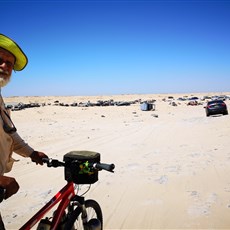
No man's land between Mauritania and Western Sahara
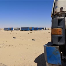
No man's land between Mauritania and Western Sahara
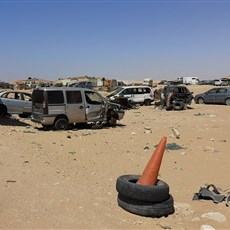
No man's land between Mauritania and Western Sahara
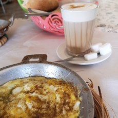
Guerguerat restaurant
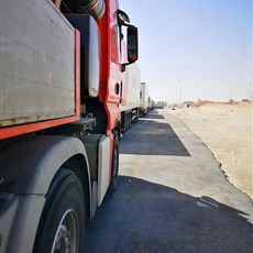
Border queue, Guerguerat