2000 Biking New Zealand
Day 03, 10 December 2000, Sunday
Queenstown – Wanaka; 77.1km @ 15kph, Wanaka
Bakpaka, $44
Today we crossed the Crown
Range – at 1 100m the highest public
road in New Zealand.
And pretty exhausting it was too – especially in light of the fact that we were
both already / still tired from our previous two days on the road.
We were packed and ready to go by 7.30am.
Just as we were leaving the motor park the Walls arrived and, yippee, relieved
us of our luggage. We pumped our tyres and hit the road. And I knew immediately
it was going to be a long day. Sore bum and hands; leaden legs.
But nice enough weather: Cool, cloudy, dry
and windless. We spent our Sunday in a rural New Zealand: Cocks a-crow, mom and
dad ducks watching over their young a-roam in the damp green grass, tourists
and locals at their leisure.
Our first stop was on the bridge at
Arthur’s Point (Arthur discovered gold in the area in the late-1800s) to watch
the Shotover Jet Boat company scare the hell out of paying clients by zooming
far too close to canyon rocks for safety. Despite a few steepish climbs –
including one that led to a rural post box for someone appropriately named Strain
– the road to Arrowtown, our breakfast destination, was basically pleasant. (We
have been amused at the post boxes we have seen en route to date, particularly
a brightly patterned version for people named Patton!)
Arrowtown, 19km from Queenstown, is a cute
restored gold mining town with wooden buildings, lovely trees and tourist
shops. We breakfasted in a café here on delicious lamb and satay pies, and
coffee. And purchased some pastries for the eating of later. David made some
enquiries on our behalf and found we could cut several km off our route if we
walked Tobin’s Track rather than cycling back to the main road and then turning
again to tackle the Crown
Range.
Tobin’s Track is 2.2km long and leads from
the town to the plateau part way up the Range. It is rutted dirt and steep. And
cycleable only for those who have the strength and ability. In fact, the ‘Pub
to Pub’ cycle race goes from an Arrowtown pub to the Cardrona pub on the other
side of the summit along this track each year – and on this very day. We
literally saw the back end of the cyclists disappearing up the heavily-bushed
track as we turned onto it. I walked every shattering cm, brought nearly to
tears at times by a daunting tiredness and a feeling that there was no way in
hell I was going to manage the day.
I coped OK with the plateau despite it
being fairly rough – corrugated, in fact – with gravel and dust and walked the
bulk of the remaining 7-or-so km to the summit, the dirt road being just too
steep for me to cycle. It was icy cold at the top where we were met by the
Walls bearing our pastries which we ate with pleasure (though we stupidly
forgot to have what would have been a very welcome swig of cognac from Kerrin
and Hugh’s hip flask!) and where we were rewarded with fantastic views back
down the mountain we had conquered and the surrounding countryside.
We also met a young man who had cycled the
40-uphill km from Wanaka “just for fun”. When I said I thought he was mad, he
looked at my bike and I with raised eyebrows and asked the inevitable: “So
what’s your excuse?” Mmmm…good question.
Then down t’other side – the first 14km
exhilarating and fast despite the headwind we encountered this side of the
Range. Down, down, down to the pub at Cardrona. For tea and our goodbyes to the
Walls. (They got married in this pub and love the area. In fact, it was only
because they knew for sure that the descent side of the Range had been sealed
since Lonely Planet were there, that I had been persuaded to tackle the Range
at all. And in the long run this proved a better choice than the busier, longer
route via Cromwell.)
After the mad downhill rush we entered a
gentler valley, the road following and crossing (11 times) the Cardrona River. We cycled sometimes in an
almost-silence. Just the rustle of trees, the whirr of tyres on tar, the baah
of surprised sheep, the murmur of running water. With poplars, and willows and
conifers in greens and grey-greens. (Charl noted a particular poplar apparently
planted by school children from a now non-existent school as a flag pole to
commemorate the relief of Mafeking
during the second Anglo-Boer War.) And a cemetery with a sign on the wall
proclaiming “Telephone cables buried here”! The scenery in general less
dramatic than on the south side of the Range, but prettier to me. All tumbled
tumbling hills. The easy route made tough by the wind. But little traffic to
ruin our day.
By the time we arrived in pretty laid-back
Wanaka on the shores of Lake (you guessed it)
Wanaka with its impressive backdrop of snow-covered peaks, we were very ready
to call it a day… So showered and walked into town where we had a pretty good
Thai meal and chatted later in the pedestrian street to American Jeff Phillips
who paints and sells river rocks for a travel-living. He calls his artworks
Chak-Roks after chakras, the “…spiritual / neurophysiological centres or
vortices along the spinal column through which we receive and transmit the
energies of life…” His rock paintings contain symbols “real or imaginary” and
are dedicated to the “beauty, health and well-being of the myriad life-forms,
the passengers / crew of Spaceship Earth and all of her Gaian sister planets
elsewhere in the cosmos”.
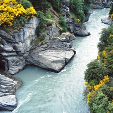
Shotover Gorge
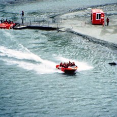
Shotover Gorge
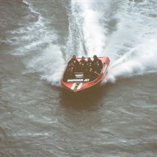
Shotover Gorge
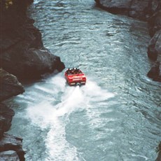
Shotover Gorge
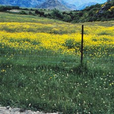
Arrowtown
Tobin's track
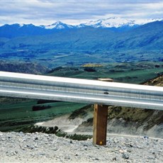
Crown Range
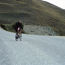
Crown Range
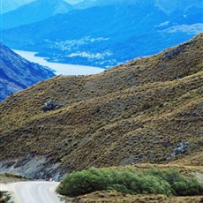
Crown Range
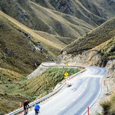
Crown Range
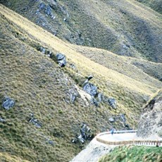
Crown Range
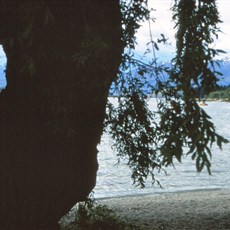
Lake Wanaka
Lake Wanaka